The 100-Mile Wrinkle: Capitol Reef’s Waterpocket Fold
Posted in: Outdoor adventures on May 10, 2026.
The 100-Mile Wrinkle
So here’s a fun one. You know how Capitol Reef is full of cliffs and domes and canyons that don’t look quite like anywhere else? There’s basically one reason for all of it, and it’s got a great name: the Waterpocket Fold.
A “fold,” in geology, is pretty much what it sounds like. Rock that used to lie flat got bent by pressure from below. This one’s the kind geologists call a monocline, which is a fancy way of saying it’s one giant step instead of a full wave. The layers sit more or less level, climb thousands of feet along a seam, then level off again up top. (On the west side they end up about 7,000 feet higher than where they started. Rocks do strange things when you give them 50 million years.)
And it’s big. The step runs about 100 miles, from Thousand Lake Mountain in the north clear down toward Lake Powell in the south. The whole of Capitol Reef National Park follows it.
It buckled up some 50 to 70 million years ago, back when the same forces were busy raising the Rockies. Those forces quit a long time ago. But here’s the strange part: the fold didn’t actually show itself at the surface until much more recently, once the rock on top eroded away. That carving is still going on. The view out your car window is the ongoing work of wind, water, and the Fremont River.
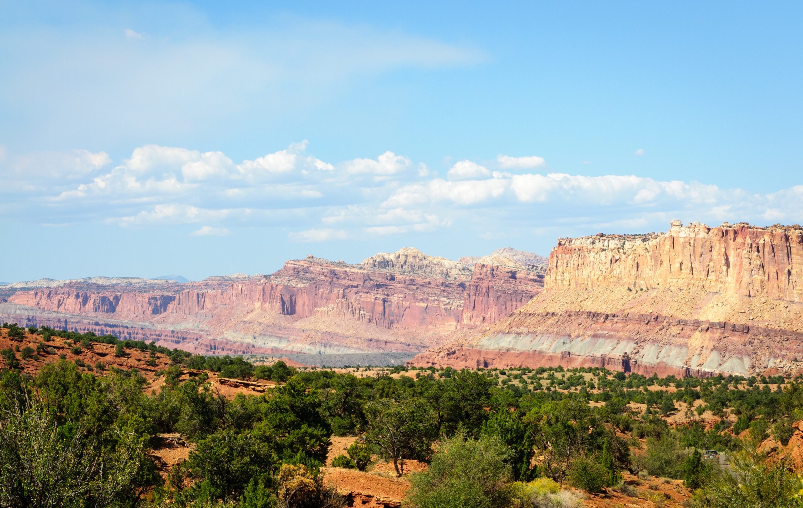
The tilted layers of the Waterpocket Fold, seen from Panorama Point. Photo by Zack Frank courtesy of Shutterstock.
Why the Park Is Shaped Like a Ribbon
Most national parks are blobs on a map. Capitol Reef is a long, skinny band — almost absurdly skinny for how long it is. Pull up the boundary sometime and see for yourself.
That shape isn’t an accident. The park was drawn to follow the fold. Just about everything inside the line is either part of the wrinkle, something erosion carved into it, or close enough to see from the road. It’s the reason the drive from Fruita out to the Burr Trail feels like you’re reading the same long geological sentence for a couple of hours.
How to Read the Rocks
Once you know what you’re looking at, the layers start to read like stripes on a flag. Each color band in the cliffs is its own layer — sandstones, mudstones, shales — laid down at different times in wildly different worlds. The reddish-brown bands were river mud and sand. The pale cream ones were sea beaches or old dune fields. The greens and grays settled out of quiet water, a long, long time ago.
And because the fold tilted all of it up on end, a hike at Capitol Reef can feel like walking through time. Head one way and you’re stepping into older rock. Head the other and it gets younger. The Chimney Rock trail is a short, easy place to see it for yourself: you climb up out of the soft red Moenkopi mudstone into the harder Shinarump caprock that’s held that tower together for something like 245 million years.
And honestly, the park’s 18-minute orientation film at the Visitor Center (it’s called Watermark) is worth sitting down for, for exactly this reason. It’s a better introduction than any blog post can give you — this one included.
About That Name
There’s a good story tucked into the name. “Capitol” came from the white domes of Navajo sandstone you’ll see around the park — the early settlers thought they looked like the Capitol building back in Washington. “Reef” was their word for any rocky barrier that stopped a wagon, and the fold was exactly that: a wall of rock they couldn’t get across. The name stuck.
And the “Waterpocket” part points to something worth knowing too. The sandstone holds natural basins that catch rainwater and keep it for weeks after a storm. Travelers learned to find them. Out here, a pocket of water could be the difference between making the next town and not.
Where to See It Best
A few spots lay the fold out better than others:
- Panorama Point. The view most people picture when they think of Capitol Reef. The fold is spread out in front of you like a cross-section diagram.
- The Scenic Drive. Cuts right through the tilted layers. Every pullout is a new angle on the same thing.
- Burr Trail Switchbacks. Maybe the single best look at the fold from above, gazing back toward the park.
- Strike Valley Overlook. Once you’re there, it’s only a 0.4-mile walk to a view of the fold running to the horizon in both directions. Getting there is the catch — the last stretch of the Upper Muley Twist spur is sandy and rocky and really does want a high-clearance 4WD. Check conditions at the Visitor Center before you commit.
The Shift in Seeing
There’s a moment that tends to happen around the second or third day. You stop noticing the rocks and start noticing the structure — the way every cliff and canyon and arch is part of the same hundred-mile wrinkle. It’s a small shift, and it quietly changes the whole trip.
So next time you’re out on the Scenic Drive, look for the step. Once you see it, you can’t unsee it. And if you need a place to come back to at the end of the day, we’ve got rooms a few minutes up the road.